Captain John Smith
Captain John Smith’s Chesapeake Bay Journeys
Four hundred years ago, Englishman John Smith and a small crew of adventurers from the Jamestown Company set out in an open boat to explore the Chesapeake Bay. Between 1607 and 1609, Smith and his crew mapped nearly 3,000 miles of the Bay and rivers and documented American Indian communities. His leadership at Jamestown, his contacts with Chesapeake Indians and his Chesapeake Bay voyages – documented in maps and journals – helped ensure the success of early English colonization efforts. Smith’s map and journals are a remarkable record of the 17th-century Chesapeake.
For the Hyperlink for a brief overview of the Captain John Smith Trail.
Come join the adventure on the Chesapeake Bay!
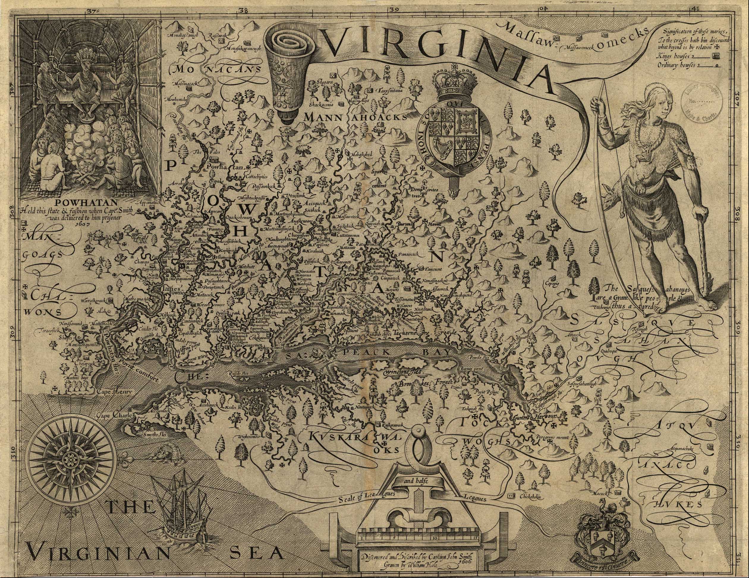
Captain John Smith created the first detailed map of the Chesapeake Region. His masterpiece map of Virginia, published in 1612, remained in active use for seven decades and opened this part of North America to European exploration, settlement, and trade. The geographical accuracy is astounding given that Smith traveled about 2500 miles in a series of short expeditions and had only primitive map making tools to work with.
Smith’s map records not only the geographic features of the Chesapeake, but also its cultural aspects, including more than 200 Indian towns. Many of the place names remain in use today.
Together with his journals, Captain John Smith’s map provides an unparalleled record of what the Chesapeake was like four centuries ago.
The historic routes of Captain John Smith may be accessed from hundreds of points throughout Virginia, Maryland, Delaware, Pennsylvania, and the District of Columbia.
There are multiple ways to find directions for your preferred trail access point. Consult the Boater’s Guide and head out on a river to see the Chesapeake through the eyes of Captain John Smith. Download the whole Guide or just the section you want to explore. The Boater’s Guide provides instructions for scouting your trip using Google Earth (on page 14), and also provides links to online maps for access points on 12 sections of the trail.
To enjoy the trail from land, try geocaching at more than 50 places along the Captain John Smith Geotrail. You’ll need to set up a free registration at www.geocaching.com and then download GPS coordinates on the geotrail’s webpage at www.geocaching.com/adventures/geotours/captainjohnsmith.
Detailed information about trail access sites, including maps and trail guides, is available at many locations and water trails around the Chesapeake Bay. Visit www.smithtrail.net to discover the existing water trails that follow portions of John Smith’s historic journey and the many other sites that offer access to the trail.
You do not need a permit to boat or paddle the Smith trail, aside from licenses that may be required by the states of Virginia, Maryland, Delaware, or the District of Columbia. There are no fees required to use the trail. However, the sites and access points associated with the trail are owned and managed by many different organizations, including state, federal, local, public, and private. Some sites may charge fees and/or require advance reservations. We do not. The Watermen’s Museum is proud to be an official Gateway of the National Park Service’s John Smith Water Trail.
You can access maps of the Captain John Smith Trail at this link. http://www.nps.gov/cajo/planyourvisit/maps.htm